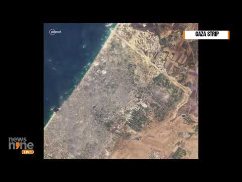
- Recent satellite images reveal significant destruction in Gaza, particularly in Beit Hanoun, but are outdated, dating back to October and November 2023.
- Access to real-time satellite imagery is hindered by regulatory issues and cautious private companies during ongoing conflicts.
- The humanitarian crisis in Gaza is exacerbated by a high death toll, estimated to exceed 46,000, with experts warning the actual number may be 40% higher.
- A tentative ceasefire allows limited movement, yet uncertainty and fear of renewed hostilities remain prevalent.
- The situation in Gaza highlights an urgent need for timely humanitarian aid and a lasting resolution to the conflict.
In a harrowing showcase of devastation, the latest satellite images of Gaza unveil scenes of destruction that echo the turmoil experienced on the ground, particularly in the Beit Hanoun neighborhood. Although these updates have recently appeared on Google Earth and Maps, they date back to October and November 2023, leaving a significant gap in real-time imagery amidst ongoing conflict.
The quest for clarity isn’t only confined to Gaza; similar delays plague satellite imagery from war-torn regions like Ukraine and even bustling metropolises such as New York. This stagnation stems from a combination of regulatory hurdles and cautious private companies, some of which have restricted access to Gaza’s terrain following the intensified violence.
As families in northern Gaza tentatively return to search for remnants of their lost homes and loved ones, the weight of grief hangs heavy. The first phase of a ceasefire agreement has allowed limited movement, offering a glimmer of hope amid despair. Yet the uncertainty looms, as the threat of renewed hostilities remains ever-present.
With an alarming death toll surpassing 46,000, and experts suggesting the actual count could be up to 40% higher due to unaccounted deaths, the humanitarian crisis continues to deepen. As the world watches, it’s clear that the real story of Gaza extends beyond satellite images—it’s a profound tragedy of loss and resilience.
Takeaway: The plight of Gaza persists in the shadows of outdated technology, underscoring the urgent need for immediate humanitarian response and a resolution to end the suffering.
Destruction in Gaza: Realities Beyond the Satellite Images
The ongoing conflict in Gaza has generated harrowing satellite imagery that portrays not only the physical devastation of the region but also the deep humanitarian crisis unfolding on the ground. Recent reports indicate that the situation is evolving daily, with new developments highlighting both the extent of destruction and the challenges in obtaining real-time data.
Documented Challenges in Satellite Imagery
While satellite images from Google Earth and Google Maps reveal a grim landscape, they may not accurately reflect the current reality due to delays in imaging and access restrictions. Reasons include:
– Regulatory Hurdles: Compliance with government restrictions can slow the release of images.
– Private Company Caution: Companies reluctant to provide detailed imagery due to security concerns, especially in volatile regions.
Recent technology advancements have introduced high-resolution imaging satellites, but many remain constrained by geopolitics. Companies like Maxar and Planet Labs are navigating these challenges while attempting to maintain accuracy and integrity in their data.
The Human Cost
With reports of over 46,000 reported deaths, and estimates suggesting the figure could be significantly higher due to unreported casualties, the scale of human loss is staggering. Families are now grappling with the aftermath, as many return to the rubble of their former lives. Basic necessities like food, clean water, and medical care are severely lacking, deepening the humanitarian crisis.
Related Questions
1. What is the current status of the ceasefire in Gaza?
The ceasefire has allowed limited movement and humanitarian access, but the situation remains tense, with the potential for renewed conflict looming. Humanitarian aid organizations are working to provide assistance, but access is often restricted.
2. How are satellite imaging technologies evolving to better serve regions in conflict?
Newer satellites offer enhanced capabilities, such as higher resolution and the ability to image more frequently. However, ethical considerations remain important, and companies are balancing the need for public information with legal and security obligations.
3. What are the implications of outdated satellite imagery on humanitarian efforts?
Inaccurate or delayed satellite images can hinder the ability to assess damage accurately, making it challenging for aid organizations to coordinate effective responses and target resources where they are most needed.
Key Insights
– Emerging Technologies: Advances in satellite technology could improve real-time coverage, but political and regulatory barriers persist.
– Continued Advocacy: Humanitarian agencies are advocating for greater access to conflict zones for accurate assessments which can lead to more effective aid deployment.
Conclusion
The devastation in Gaza serves as a stark reminder of the need for updated technology and humanitarian strategies in conflict zones. Real-time imagery could be a crucial tool in addressing the ongoing crisis, ensuring aid reaches those who need it the most.
For more information, visit the [United Nations](https://www.un.org), a reliable source for updates on humanitarian efforts and crisis management.