Transforming Drought Management in Western Riverina
In the heart of the western Riverina, innovative satellite mapping technology is rewriting the rules for farmers like Bill and Pip Ryan. This cutting-edge system, developed as part of the Managing Rangelands for Drought Resilience project, offers a predictive approach to managing groundcover during dry spells.
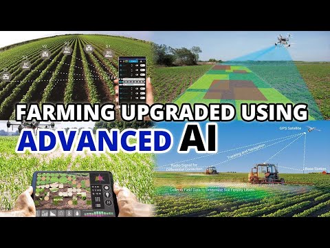
The GEOGLAM Rangeland and Pasture Productivity (RaPP) tool, created by CSIRO, the Australian Government, and the National Landcare Programme, showcases its effectiveness on the Ryan’s expansive 130,000-hectare property named ‘Curragh’. Collaborating with expert Dr. John Leys, the Ryans harness this technology to make proactive decisions regarding feeding and stocking rates.
The RaPP tool provides farmers with monthly satellite data detailing three essential vegetation cover types: green growing, dead non-growing, and bare ground. This data allows farmers to adjust management strategies based on vegetation cover levels, particularly in August, when a significant drop below 55% indicates impending drought conditions.
The insights gained from this satellite technology empower farmers to react in advance of critical dry spells, facilitating timely and informed decisions. Cindy Cassidy, director of the Southern NSW Innovation Hub, emphasizes the importance of enabling farmers to anticipate and mitigate the effects of drought.
This pioneering initiative illustrates the growing role of agricultural technology in modern farming, ultimately aiming to enhance resilience in the face of climate challenges. For more on this innovative mapping tool, visit [RaPP Mapping Tool](https://map.geo-rapp.org/).
Transforming Drought Management: Beyond the Farm
The adoption of advanced technologies like the GEOGLAM Rangeland and Pasture Productivity (RaPP) tool in the western Riverina transcends the immediate benefits for individual farmers, indicating a seismic shift in agricultural practices with far-reaching societal and economic implications.
Societal Impact: As climate variability intensifies, the resilience of farming communities is crucial. Systems that empower farmers to make data-driven decisions not only safeguard livelihoods but enhance food security at a regional scale. This technology fosters a culture of adaptability, allowing farmers to collaborate and share knowledge, which can bolster community solidarity during challenging times.
Global Economic Implications: Such innovations may dictate the future of agricultural productivity globally. Countries facing similar challenges in drought-prone areas can replicate these technologies, potentially leading to improved yields and stabilized agricultural markets. By mitigating the risks associated with drought, economies dependent on agriculture can experience less volatility, reassuring investors and fostering international trade relationships.
Environmental Considerations: Moreover, proactive drought management contributes to sustainable land use, minimizing the ecological footprint of farming. With better data, farmers can optimize their resource use, reduce overgrazing, and enhance soil health. This shift towards precision agriculture may alleviate some pressures on water resources, a critical issue as climate change escalates.
In the long term, the integration of satellite technology in agriculture is poised to redefine farming practices worldwide, creating resilient systems that not only withstand drought but also promote environmental stewardship and economic stability.
Revolutionizing Drought Management in Australian Agriculture with Satellite Technology
Transforming Drought Management in Western Riverina
The western Riverina is witnessing a groundbreaking transformation in drought management through innovative satellite mapping technology. This progress is part of the Managing Rangelands for Drought Resilience initiative, aimed at equipping farmers with advanced tools to navigate the challenges posed by dry spells.
At the forefront of this technology is the GEOGLAM Rangeland and Pasture Productivity (RaPP) tool, developed by CSIRO in collaboration with the Australian Government and the National Landcare Programme. This tool has been critically acclaimed for its role in enhancing decision-making processes for farmers, particularly on expansive properties such as ‘Curragh,’ owned by Bill and Pip Ryan.
Features and Benefits of the RaPP Tool
1. Predictive Analytics: The RaPP tool utilizes satellite data to predict vegetation cover changes, allowing farmers to make proactive management decisions.
2. Monthly Satellite Updates: Farmers receive monthly updates that categorize vegetation into three types: green growing, dead non-growing, and bare ground.
3. Drought Anticipation: Insights gathered can indicate adverse conditions ahead of time. For instance, a significant drop in groundcover below 55% can signal impending drought, allowing farmers to prepare strategies in advance.
Use Cases of the RaPP Tool
Farmers like the Ryans are using the RaPP tool to adjust feeding and stocking rates based on real-time data, improving their resilience to climate variations. By facilitating timely interventions, farmers can optimize resource use and reduce the economic impact of drought.
Insights on Agricultural Technology and Drought Resilience
Cindy Cassidy, director of the Southern NSW Innovation Hub, highlights the significant role this technology plays in empowering farmers. “The ability to anticipate and mitigate the effects of drought transforms farming practices and enhances long-term sustainability,” Cassidy notes.
Pros and Cons of Satellite Mapping in Agriculture
Pros:
– Early Warning Systems: Provides timely information on vegetation health, aiding in proactive decision-making.
– Resource Optimization: Helps farmers manage livestock and feed availability more efficiently.
– Sustainability: Promotes better land and resource management practices in the face of climate change.
Cons:
– Reliance on Technology: Farmers may become overly dependent on satellite data and neglect traditional farming knowledge.
– Cost of Implementation: Initial setup and subscription costs could be a barrier for smaller farming operations.
Market Trends and Innovations
The use of satellite technology in agriculture is on the rise globally, driven by increasing climate uncertainties. Innovations in remote sensing and data analytics are expected to revolutionize farming practices across regions facing similar challenges. Predictions suggest a continued shift towards precision agriculture, where technology plays an integral role in enhancing productivity and sustainability.
Security and Sustainability Aspects
As with any modern technology, the implementation of satellite mapping tools raises questions about data security and privacy. It’s essential for farmers to ensure that the data shared is protected. Additionally, sustainable practices driven by these technologies can contribute significantly to environmental stewardship, promoting healthier ecosystems and soil management.
For more insights into the tools transforming farming practices, visit CSIRO.
The evolution of satellite mapping technology heralds a new era for drought management and resilience in agriculture, making it a pivotal resource for farmers facing the realities of climate change.