- The ONGLAISAT satellite has achieved remarkable 2.5-meter resolution imagery from a compact design.
- Collaboration with Taiwan’s space agency enhances technological advancements in satellite imaging.
- The satellite is positioned 400 kilometers above Earth, utilizing advanced optical equipment for clarity.
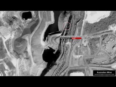
- Black-and-white images showcase detailed landscapes and urban areas, demonstrating high-quality visuals.
- The development involves partnership with the University of Tokyo, signaling innovation in small satellite technology.
- ONGLAISAT’s success underlines Taiwan’s efforts to bolster its space capabilities amid geopolitical tensions.
- This breakthrough encourages future advancements in remote sensing missions using miniature satellites.
A groundbreaking achievement in satellite technology has emerged from Japanese startup ArkEdge Space, showcasing stunning imagery that could redefine Earth observation. The ONGLAISAT satellite, developed in collaboration with Taiwan’s space agency, has successfully captured breathtaking 2.5-meter resolution images from a compact, cube-sized spacecraft—smaller than a suitcase!
Launched into orbit approximately 400 kilometers above our planet, ONGLAISAT utilized advanced optical equipment to deliver images clearer than traditional aerial photography. ArkEdge’s CEO expressed pride in this remarkable feat, noting the unprecedented quality of the pictures obtained. Black-and-white snapshots released by the company reveal intricate details of landscapes, trees, and urban areas from places like a Seattle suburb and Argentina’s picturesque Patagonia.
The ONGLAISAT—which stands for “onboard globe-looking and imaging satellite”—illustrates the potential of small satellite technology, co-developed with a University of Tokyo aerospace lab. While its mission is set to conclude in early March, the innovative optical technology demonstrated here will pave the way for future remote sensing missions.
This technological leap comes at a crucial time for Taiwan, as tensions with China escalate. The island is rapidly enhancing its space capabilities, including launching new weather satellites and forming strategic partnerships with Japanese space firms. This collaboration marks a significant step forward for Taiwan’s ambitions in the space arena, strengthening ties with allies while pushing the boundaries of what tiny satellites can achieve.
Key takeaway: Small satellites like ONGLAISAT are revolutionizing Earth observation, proving that size doesn’t limit capability in the world of space exploration.
A New Era in Earth Observation: The Game-Changing ONGLAISAT Satellite
As satellite technology continues to advance, new players are emerging in the space industry, showcasing innovations that promise to reshape Earth observation. One of the most notable is the ONGLAISAT, a compact satellite developed by Japanese startup ArkEdge Space in collaboration with Taiwan’s space agency. With its remarkable 2.5-meter resolution imagery capabilities, this miniature satellite is generating buzz in the aerospace community and redefining how we gather environmental data.
Specifications and Innovations
– Size & Design: The ONGLAISAT is cube-sized, significantly smaller than traditional satellites, making it more cost-effective and easier to launch.
– Image Resolution: Achieves an impressive 2.5-meter resolution, surpassing many existing remote sensing technologies.
– Optical Technology: Utilizes advanced optical equipment that enhances image clarity beyond traditional aerial photography.
– Orbit Height: Positioned approximately 400 kilometers above Earth, optimizing its observational capacity.
Use Cases and Applications
The imagery produced by ONGLAISAT can be utilized for various applications, such as:
– Urban Planning: Helps city planners visualize urban growth and infrastructural needs.
– Environmental Monitoring: Provides critical data concerning deforestation, climate change, and more.
– Disaster Response: Aids in assessing damage and coordinating emergency responses following natural disasters.
Pros and Cons
Pros:
– High-resolution imaging accessible via a smaller and more affordable satellite.
– Potential for frequent revisit times, allowing for updated observations.
– Encourages collaboration between nations in space exploration.
Cons:
– Limited mission duration (scheduled to conclude by early March).
– Challenges in data processing and storage due to high-resolution outputs.
– Dependence on favorable launch conditions and orbital stability.
Future Implications and Trends
The success of the ONGLAISAT indicates a promising trend toward smaller, more capable satellites enhancing global monitoring capabilities. As countries like Taiwan strengthen their space programs amidst geopolitical tensions, this advancement could lead to more partnerships and collaborations, influencing the landscape of satellite technology.
Key Questions and Answers
1. What makes the ONGLAISAT unique compared to traditional satellites?
– The ONGLAISAT combines a highly compact design with advanced optical technology, achieving high-resolution imagery that rivals larger satellites while being significantly more cost-effective to launch and operate.
2. How does this technology impact future satellite missions?
– The innovations demonstrated by ONGLAISAT set a precedent for future small satellites, potentially accelerating the development of various space missions that require high-resolution data without the constraints of larger satellite systems.
3. What role do geopolitical factors play in satellite technology development?
– Geopolitical tensions, particularly in regions like Taiwan, drive nations to enhance their space capabilities as a means of asserting independence and strengthening alliances, thus fostering rapid advancements in satellite technology and collaboration.
For further insights and updates on satellite technology, check out Space Daily.
Conclusion
The launch of ONGLAISAT signifies not just a technological achievement, but a strategic milestone for Taiwan and its partnerships. As Earth observation enters a new epoch, the implications for environmental monitoring and geopolitical strategy will continue to unfold. The ONGLAISAT is poised to make waves in how we perceive and interact with our planet through the lens of advanced satellite technology.